River Jordan, Aigburth

River Jordan, Aigburth

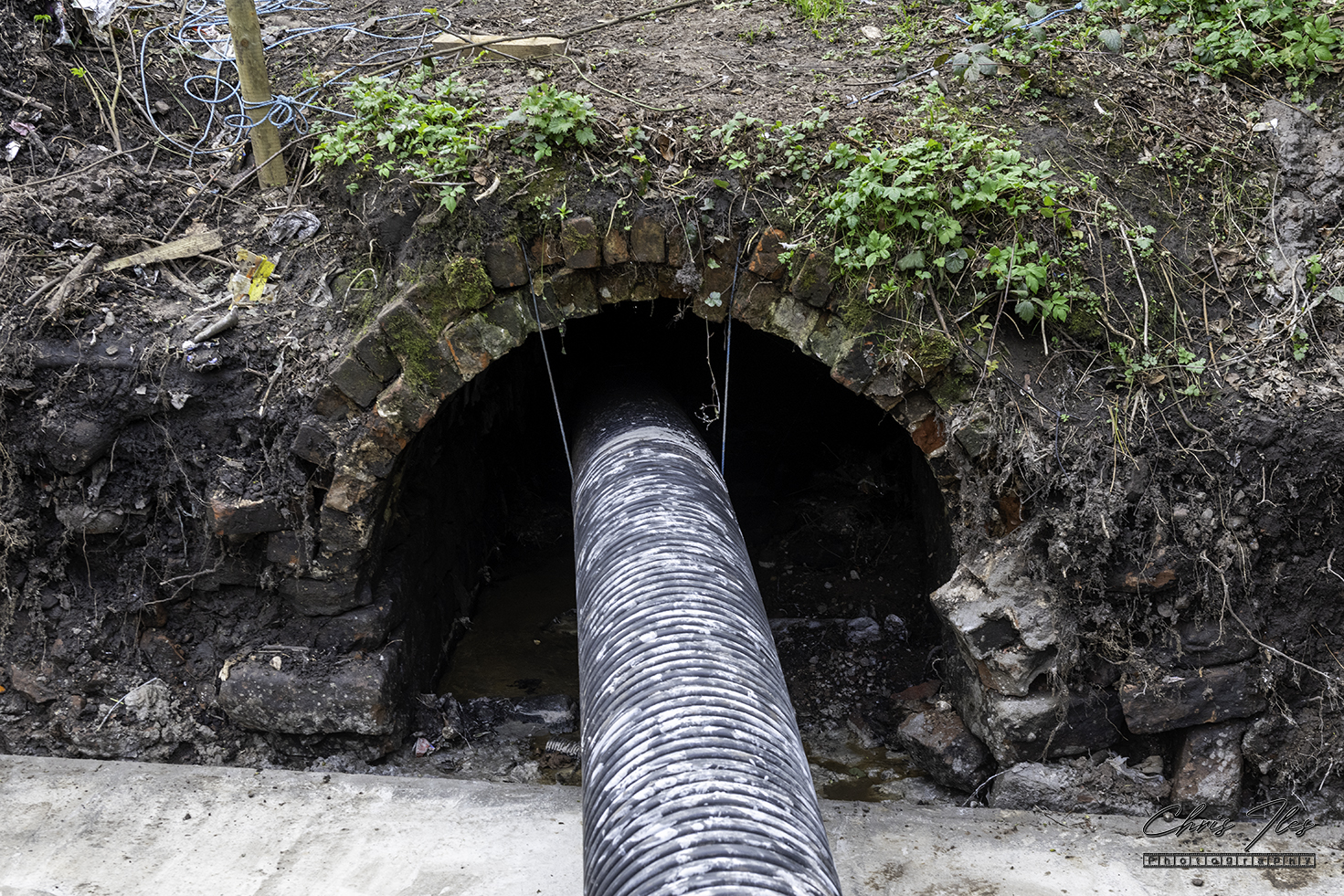
In Liverpool’s historic past, there were ancient rivers, which strangely do not seem to exist anymore. However, many of these rivers still flow down to the Mersey. There existance largely hidden from view, flowing through a network of underground brick built culverts.

Plan from: 'Underground Liverpool' by Jim Moore
The Ancient Rivers of Aigburth. (A plan from: ‘Underground Liverpool’ by Jim Moore).

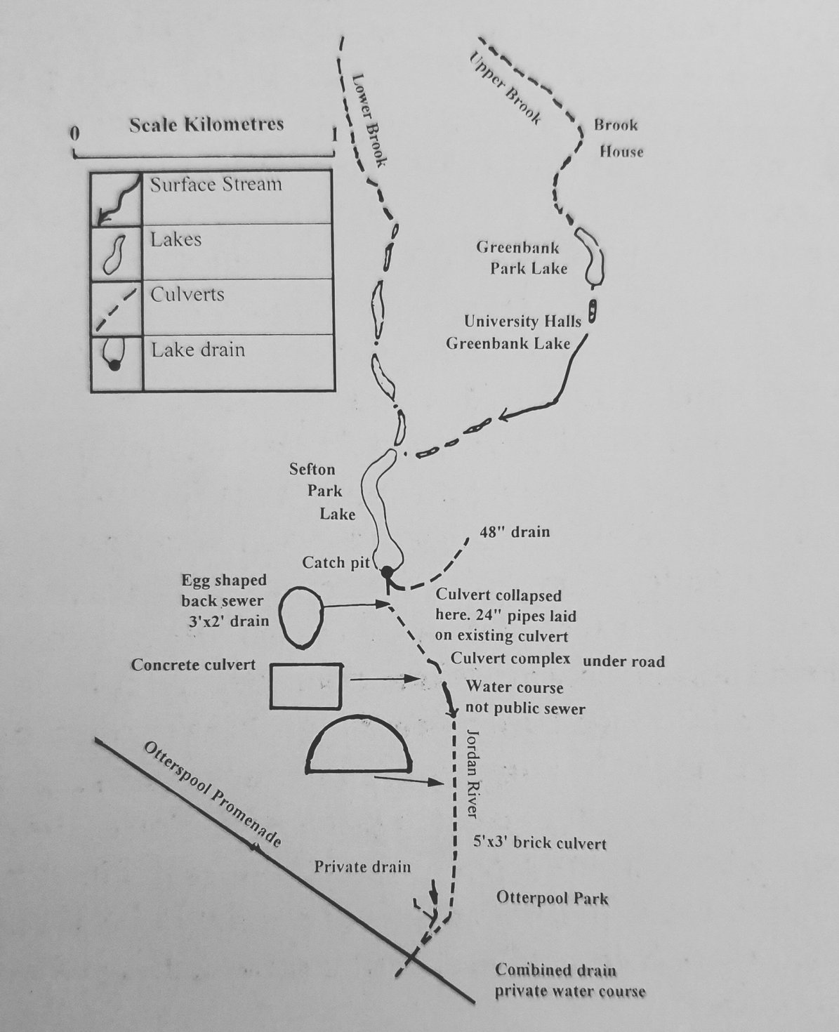
The course of these rivers were changed in the 19th century to form a series of ornamental water features for the new parks being built in South Liverpool. The “Upper Brook”, sourced near Wavertree, flowed close by the Brook House pub on Smithdown Road, so named because of it’s proximity to the nearby Brook. It then flowed into Greenbank Park to form Greenbank Lake, then into Sefton Park at the Fairy Glen. Whilst the “Lower Brook” thought to be sourced in Wavertree Botanic Gardens, formed two ponds near Edge Lane, flowing into the Grotto caves, on the edge of Sefton Park.

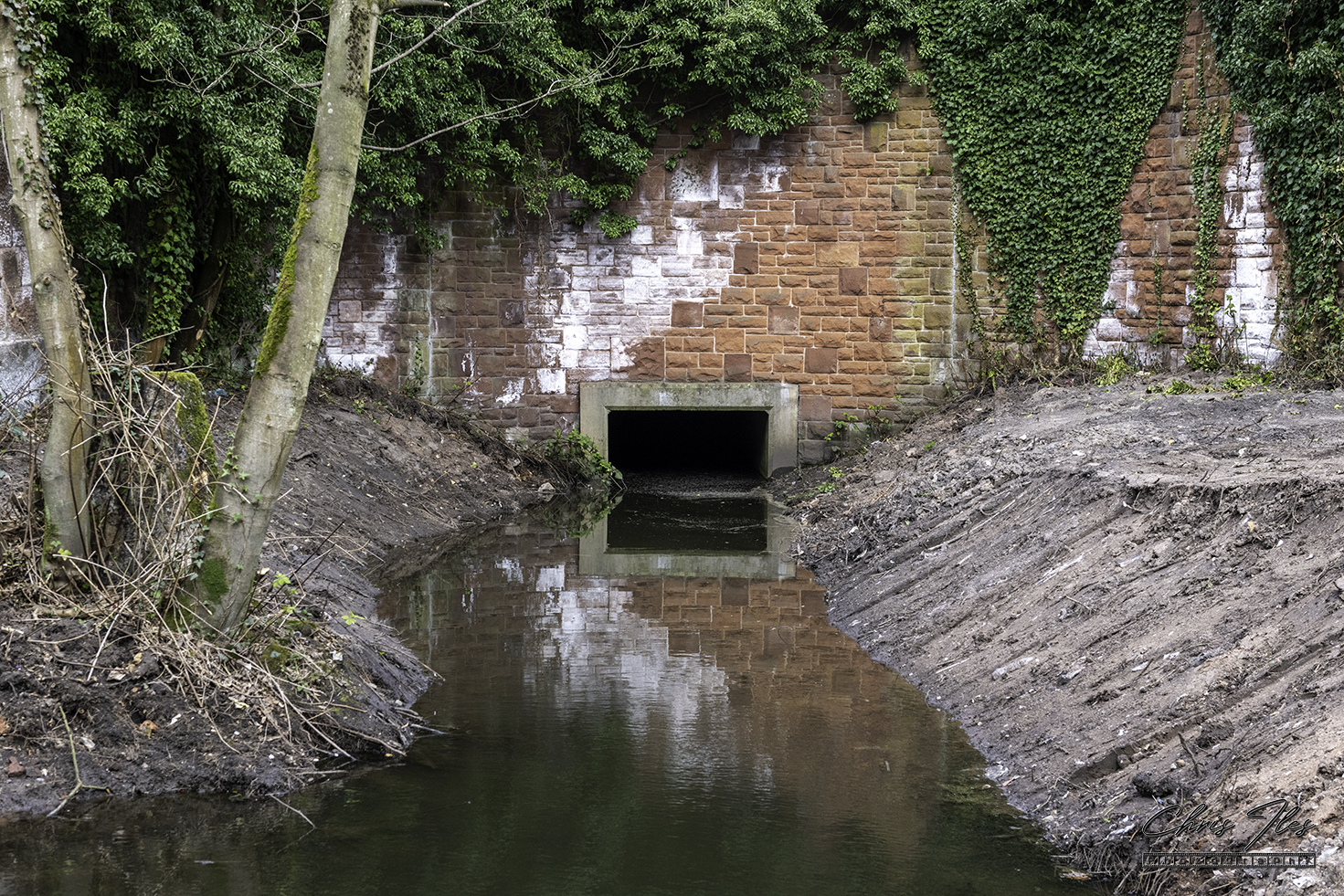
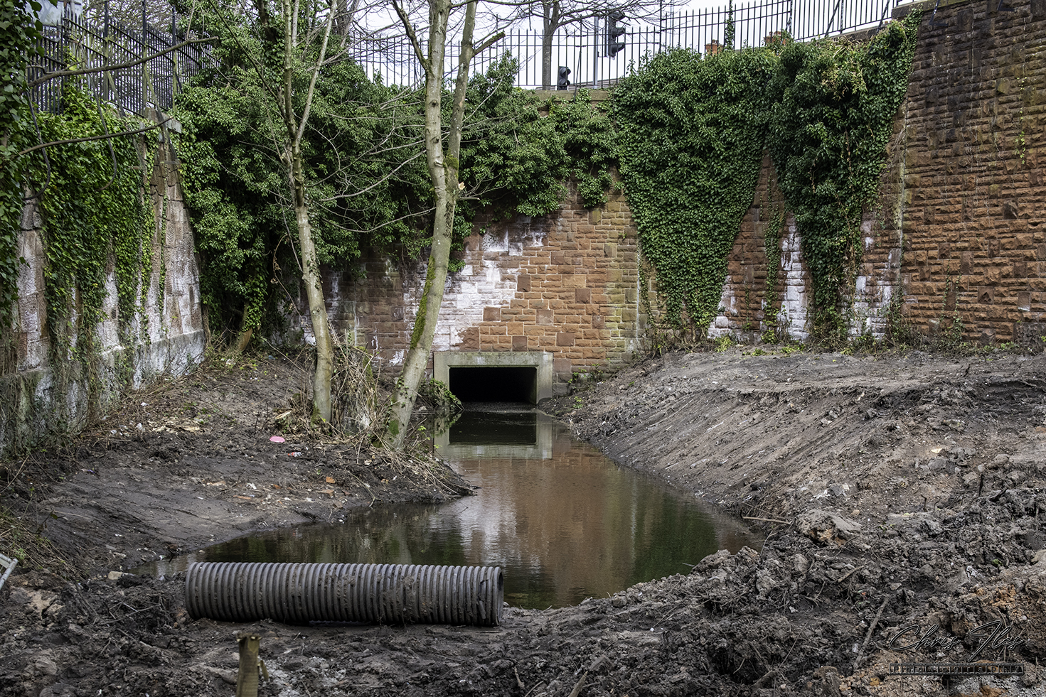
Both the Upper and Lower Brook’s continue flowing through the Park, merging together to form Sefton Park lake. The River Jordan then flows out of the lake at Aigburth Vale, vanishing beneath Aigburth Road dual carriageway, briefly re-emerging above ground near the gates of Otterspool Park. From here, the river vanishes below ground once again into brick built culverts, until finally flowing out into the river Mersey.

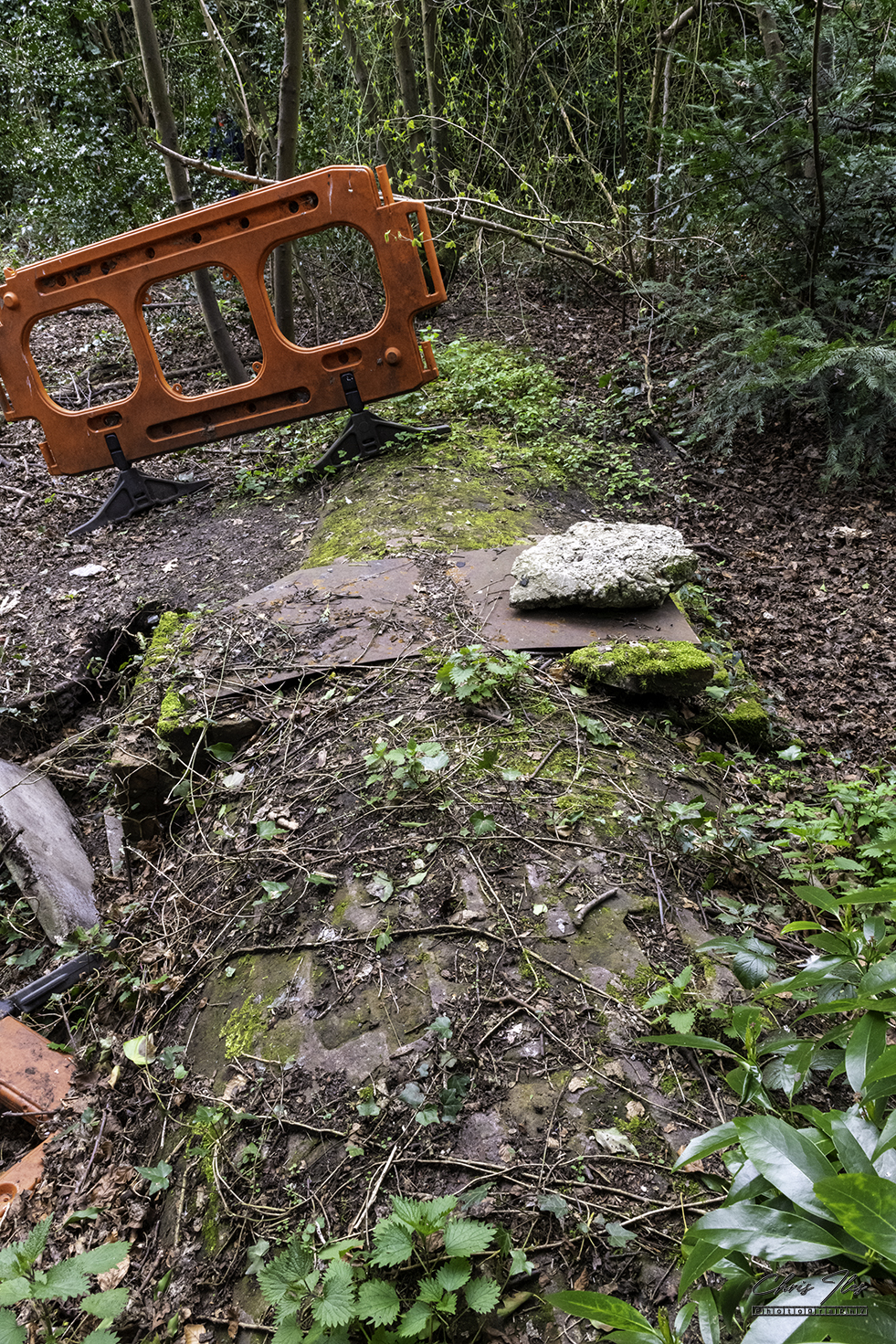
It is within Otterspool Park that most of these photographs were taken, they show the river Jordan as it emerges into Otterspool park and the otherwise unseen brick culvert that can be seen if you look carefully amongst the trees and undergrowth. However the last photograph, shows the Upper Brook emerging into Greenbank Lake.
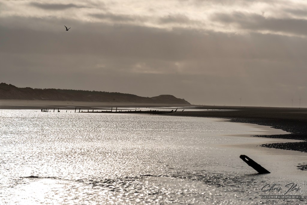

Subscribe to:
Chris Iles – Photography | chrisiles.co.uk

Join 11 other subscribers.

10 responses to “River Jordan, Aigburth”

  1. Discovered: The ancient boundaries of Toxteth Park. I also rechart the boundaries of Liverpool and Everton, before 1207. – The Priory and the Cast Iron Shore avatar

    […] The landscape of Liverpool and Toxteth Park was dominated by water – The Mersey of course, the ‘Pool’ of Liverpool, the stream that later fed ‘Mather’s Dam’, the Dingle, Dickenson’s Dingle met the Mersey at St. Michael’s Hamlet. That was used to create Prince’s Park lake. In the south east are also the Upper and Lower Brooks that were used to form Sefton Park Lake. After these two brooks joined, they formed the ‘River Jordan’ and run underground at Aigburth Vale and then to the Mersey at Otterspool. […]

    Like

  2. Discovered: The ancient boundaries of Toxteth Park. I also rechart the boundaries of Liverpool and Everton, before 1207. – The Priory and the Cast Iron Shore avatar

    […] The landscape of Liverpool and Toxteth Park was dominated by water – The Mersey of course, the ‘Pool’ of Liverpool, the stream that later fed ‘Mather’s Dam’, the Dingle, Dickenson’s Dingle met the Mersey at St. Michael’s Hamlet. That was used to create Prince’s Park lake. In the south east are also the Upper and Lower Brooks that were used to form Sefton Park Lake. After these two brooks joined, they formed the ‘River Jordan’ and run underground at Aigburth Vale and then to the Mersey at Otterspool. […]

    Like

  3. Discovered: The ancient boundaries of Toxteth Park. We also rechart the boundaries of Liverpool and Everton, before 1207. – The Priory and the Cast Iron Shore avatar

    […] The landscape of Liverpool and Toxteth Park was dominated by water – The Mersey of course, the ‘Pool’ of Liverpool, the stream that later fed ‘Mather’s Dam’, the Dingle, Dickenson’s Dingle met the Mersey at St. Michael’s Hamlet. That was used to create Prince’s Park lake. In the south east are also the Upper and Lower Brooks that were used to form Sefton Park Lake. After these two brooks joined, they formed the ‘River Jordan’ and run underground at Aigburth Vale and then to the Mersey at Otterspool. […]

    Like

  4. […] The landscape of Liverpool and Toxteth Park was dominated by water – The Mersey of course, the ‘Pool’ of Liverpool, the stream that later fed ‘Mather’s Dam’, the Dingle, Dickenson’s Dingle met the Mersey at St. Michael’s Hamlet. That was used to create Prince’s Park lake. In the south east are also the Upper and Lower Brooks that were used to form Sefton Park Lake. After these two brooks joined, they formed the ‘River Jordan’ and run underground at Aigburth Vale and then to the Mersey at Otterspool. […]

    Like

  5. […] The landscape of Liverpool and Toxteth Park was dominated by water – The Mersey of course, the ‘Pool’ of Liverpool, the stream that later fed ‘Mather’s Dam’, the Dingle, Dickenson’s Dingle met the Mersey at St. Michael’s Hamlet. That was used to create Prince’s Park lake. In the south east are also the Upper and Lower Brooks that were used to form Sefton Park Lake. After these two brooks joined, they formed the ‘River Jordan’ and run underground at Aigburth Vale and then to the Mersey at Otterspool. […]

    Like

  6. […] The landscape of Liverpool and Toxteth Park was dominated by water – The Mersey of course, the ‘Pool’ of Liverpool, the stream that later fed ‘Mather’s Dam’, the Dingle, Dickenson’s Dingle met the Mersey at St. Michael’s Hamlet. That was used to create Prince’s Park lake. In the south east are also the Upper and Lower Brooks that were used to form Sefton Park Lake. After these two brooks joined, they formed the ‘River Jordan’ and run underground at Aigburth Vale and then to the Mersey at Otterspool. […]

    Like

  7. […] The landscape of Liverpool and Toxteth Park was dominated by water – The Mersey of course, the ‘Pool’ of Liverpool, the stream that later fed ‘Mather’s Dam’, the Dingle, Dickenson’s Dingle met the Mersey at St. Michael’s Hamlet. That was used to create Prince’s Park lake. In the south east are also the Upper and Lower Brooks that were used to form Sefton Park Lake. After these two brooks joined, they formed the ‘River Jordan’ and run underground at Aigburth Vale and then to the Mersey at Otterspool. […]

    Like

  8. […] The landscape of Liverpool and Toxteth Park was dominated by water – The Mersey of course, the ‘Pool’ of Liverpool, the stream that later fed ‘Mather’s Dam’, the Dingle, Dickenson’s Dingle met the Mersey at St. Michael’s Hamlet. That was used to create Prince’s Park lake. In the south east are also the Upper and Lower Brooks that were used to form Sefton Park Lake. After these two brooks joined, they formed the ‘River Jordan’ and run underground at Aigburth Vale and then to the Mersey at Otterspool. […]

    Like

  9. […] The landscape of Liverpool and Toxteth Park was dominated by water – The Mersey of course, the ‘Pool’ of Liverpool, the stream that later fed ‘Mather’s Dam’, the Dingle, Dickenson’s Dingle met the Mersey at St. Michael’s Hamlet. That was used to create Prince’s Park lake. In the south east are also the Upper and Lower Brooks that were used to form Sefton Park Lake. After these two brooks joined, they formed the ‘River Jordan’ and run underground at Aigburth Vale and then to the Mersey at Otterspool. […]

    Like

Leave a comment

134,341 – Site Views

13,389 – Site Visitors

854 – Page Views