
Lime Street Station | Edge Hill Station | Lime Street to Edge Hill Cutting | Maps
Liverpool Lime Street Station
Liverpool’s original terminus station on the 1830 Liverpool and Manchester Railway (L&MR), was Crown Street Station in Edge Hill. However, it was quickly realised that Crown Street station was too far away from the city centre. So Lime Street Station was built in the city to replace the original Crown Street station.


The Grand and Historic, Grade II Listed, Liverpool Lime Street Station. The ‘Oldest, Still-Operating, Terminus, Mainline Railway Station in the World’.
The new station on Lime Street, opened on the 15th August 1836, making Lime Street station the ‘Oldest, Still-Operating, Terminus, Mainline Railway Station in the World’.
Within the first six years of opening, it was apparent that expansion would be necessary due to the growth of the Railways. So a new single curved glazed roof was built over the train shed in 1849 by LNWR.


During the 2016-2018 Lime Street upgrade, three York Stone slabs were discovered. The three slabs, thought to have originated from the original 1836 platforms. Network Rail preserved, engraved and integrated the original stones into the current Platforms 1, 3 and 5, in recognition of Lime Street’s history as the Oldest, Terminus, Mainline Railway Station in the World.
However, future expansion plans of the station would see further big changes take place, helping to make the modern-day Lime Street Station that we all recognise today.
The first of the new roof sections was built in 1867, replacing the previous roof. This large northern glazed arch was the largest in the world at that time, having a span of 200ft. Then in 1879, the southern glazed arch was built alongside the first, forming the twin arches of the Lime Street Station that we see today.

The iconic twin glazed arches of the Grade II Listed, Liverpool Lime Street Station, were constructed in stages. The first being the Northern section in 1867, replacing the earlier 1849 roof. Then the Southern arch was added alongside in 1879, Completing the twin arch roof of today.


Just towards the end of the platforms and neck of Lime Street Station, up on Street level, is a nicely designed installation celebrating the early Railway and it’s engineers. The pedestrian area is designed to represent the Railway lines, below your feet. The installation consists of four, half railway wheels, each celebrating important people linked to the early Railway. Just beyond the wall, you can see the top of the Southern roof section of Lime Street
Edge Hill Station
Edge Hill Station with it’s Grade II listed buildings, is one of the oldest operating Stations in the world. It opened in 1836 and has been in continuous use ever since. The Station was built on approach to the original two track tunnel to Liverpool Lime Street Station following closure of the original Crown Street Station. When the new station was built, the existing winding house and engine house were incorporated into the station build.


Looking from the historic Edge Hill Station, down into Lime Street Cutting, towards Liverpool Lime Street Station. The short tunnel you see here, is all that remains of the original 2 track tunnel from Edge Hill to Lime Street.
Lime Street to Edge Hill Cutting
The highlight of my day as a Train Driver, based at Liverpool Lime Street for over 20 years, was the journey through the incredible Lime Street to Edge Hill cutting, enroute to London Euston. The Lime Street Cutting is an absolutely fascinating structure with an equally fascinating history. Such incredible engineering went into making the cutting we know today, with it’s bridge and tunnel structures.

Gradient Profile for the West Coast Main Line route, between Weaver Jcn, Edge Hill and Liverpool Lime Street.
Trains into the newly built Liverpool Lime Street from Edge Hill Station was initially via a two track 1.07 mile-long tunnel. Trains descended down to Lime St by gravity with a brake man. Trains were then hauled back up to Edge Hill by a stationary steam engine due to the steep gradients of 1:83 & 1:93.
It would be some years before steam locomotives would be sufficiently powerful to climb the gradient from Lime Street to Edge Hill. Locomotives did eventually start being used from 1879, meaning steam within the tunnel would become a problem. So John Ramsbottom, engineer, (1814–1897), was called upon to design a ventilation system for the tunnel. John Ramsbottom, a founder member of the “Institute of Mechanical Engineers” in 1847, later becoming the Locomotive Superintendent for LNWR from 1846-1871, and also being responsible for many other inportant rail related developments. Ramsbottom’s Vent, consisted of a chamber cut through the bedrock of the Railway tunnel wall. Within this Chamber, deep beneath the large “Ramsbottom’s Chimney“, a large steam driven extraction fan was installed. A sketch of Ramsbottom’s Chimney vent including it’s fan mechanism and the Railway Tunnel, can be seen below. However, even with Ramsbottom’s Chimney vent, steam remained problematic, so plans were drawn up to open the original tunnel into the cutting we know today. Ramsbottoms Chimney on Smithdown Lane, Edge Hill, dominated Liverpool’s skyline for many years, until finally being demolished in the 1970’s. It is believed that when the chimney was demolished, it’s brick structure was simply collapsed in on itself, burying the fan mechanism in the chamber below. In 1881, work commenced to convert the original 2-track railway tunnel into todays deep open cutting with four tracks, along with the seven smaller tunnels supporting roads and buildings above. What is astonishing, the work to open up the tunnel into todays cutting was carried out without closing the railway, completing work between trains.

View looking towards Edge Hill Station at the Top of the Lime St Cutting. Showing the original 2 track Tunnel in the centre, with the later, additional, single line tunnels at either side.
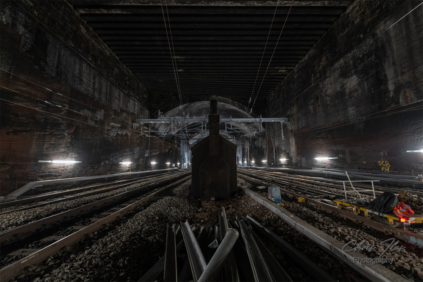
In July 2018, I was given an extremely rare opportunity to have an even closer look within the cutting, being given the authority to walk from Lime Street Station into and along the Railway Cutting, during the Lime Street blockade.
Within the cutting, in addition to Ramsbottom’s Chimney vent, there are various other features that can be seen if you look very carefully, including the old platelayers Cabin and the bricked up former Triple Decker Tunnel (one of the subterranean features of Joseph Williamson’s Tunnels). Along with the location of where the catastrophic wall collapse occurred and where the new replacement wall along the top of the cutting would be built.


Left Image: The platelayers cabin, hidden from view by the darkness within the Tunnels.
Middle Image: The New wall, built to replace an original section of wall that collapsed into the cutting.
Right Image: The long sealed Triple Decker Tunnel, hiding in plain sight. A large structure that formed part of Joseph Williamson’s Subterranean world.


Heading down the cutting, towards Liverpool Lime Street Station. A Train Drivers view, from the cab of a Virgin Trains Pendolino en route to Liverpool Lime Street station.
Left Image: Joseph Williamson’s Triple Decker Tunnel can be seen on either side of the cutting, long since sealed with large sandstone blocks.
Right Image: Image showing the portal of Ramsbottom’s Chimney vent in the cutting wall. Built to extract the steam from the original Lime Street to Edge Hill Tunnel.


A closeup view into what remains of Ramsbottom’s Vent today. Within the Brick Arch, black staining can be seen on the face of the brick, from the steam locomotives using the Tunnel. Further inside, bricks piled within the arch are the remains of the former Ramsbottom’s Chimney, when the chimney was demolished in the 1970’s. It is believed the large brick structure was simply collapsed in on itself, down into the void below, burying the original steam fan in the base.
A plan of Ramsbottom’s Chimney vent, Smithdown Lane. It shows the internal steam driven fan mechanism and the original Lime Street to Edge Hill Tunnel (marked “A”). (Copyright of this plan is not known)
A map showing the location of Ramsbottom’s Chimney, labelled “Old Air Shaft”. The Former vent for the original Lime Street to Edge Hill Tunnel, (bottom left). The Map: OS 1:1,250/1:2500, 1944-1974 Map (curtesy of National Library of Scotland).
To find out more about the fascinating history of the Lime Street to Edge Hill Cutting and how the original Tunnel was converted into today’s cutting, take a look at the fascinating “Jan Ford’s World – Edge Hill Cutting”. Jan’s report includes the most amazing series of photographs, documenting the work to open up today’s cutting.


Map showing the location of the Lime Street to Edge Hill Cutting
Open maps to view in greater detail.


A ‘Railway Clearing House map’, dated 1909, shows the Old Railways of Liverpool with a closeup of the section detailing the Liverpool to edge Hill Cutting
A Closeup map of Liverpool Lime Street, and the Lime Street Cutting to Edge Hill Station. The Map: OS 1:1,250/1:2500, 1944-1974 Map (curtesy of National Library of Scotland).
The second, is a map I purchased for my collection of Historic Liverpool maps. A ‘Kelly’s Directories’, ‘Map of Liverpool, Bootle and Suburbs 1903’, shows the Railways and stations throughout Liverpool at this time.
The extent of Liverpool’s complex Rail network as seen on an official 1959 British Railway’s rail plan of Edge Hill. The original plan being approximately 6ft wide, made scanning on an A4 scanner quite a task.
Click the maps, to view in more detail.
Media Coverage
Stunning pictures reveal a rarely glimpsed side of Lime Street station – Liverpool Echo
Views inside the deep Liverpool Lime Street railway cutting – Liverpool Echo
Random Image Galleries
Random Galleries, updated on each page refresh.


Leave a Reply